Pima Prospers Land Use Plan
Pima Prospers Comprehensive Land Use Plan
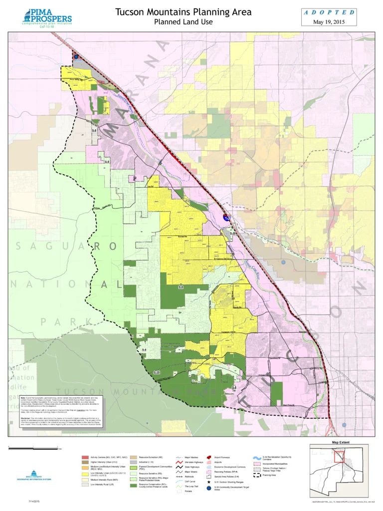
Imagine you’re standing at the edge of the Tucson Mountains, looking out over a patchwork of desert, homes, and open land. Now imagine that a developer proposes a dense housing project nearby—twice the typical number of homes, few buffers, and no plan for preserving native vegetation. How do we, as the Tucson Mountains Association, respond? This is where the Pima Prospers Comprehensive Land Use Plan becomes our compass. Adopted in 2015, it’s Pima County’s long-term vision for how land should be used—what areas should grow, and which should be protected. In our region, the map classifies much of the land as low-intensity or rural, with limited density and a focus on conservation. When a proposal doesn’t align, we can point to these official designations to make our case. It’s not just opinion—it’s policy. By understanding the plan, we become stronger advocates, guiding development to fit the landscape instead of overwhelming it.
Note: TMA serves section S-8 (Tucson Mountains North), encompassing the yellow and adjoining green regions west of the Santa Cruz river and east of Saguaro National Park.
The Pima Prospers Land Use Plan is currently undergoing revision, and TMA is actively working to ensure that the updated policies help preserve the unique character of our region.
Below is a side-by-side comparison of the 2015 plan and the draft 2025 update. Board members Steve Dolan and Debbie Hicks have been leading our efforts to engage with Pima County Development Services, advocating for improvements to key elements of the plan—particularly in areas where stronger protections and clearer guidance could better serve the Tucson Mountain region.
Visit the Pima Prospers 2025 Website for more details.
![]()
(Final: 2015)
Name: S-8 Tucson Mountains North (TM)
General Location: Within portions of Township 13 South, Range 12 East; Township 13 South, Range 13 East; Township 14 South, Range 12 East; and Township 14 South, Range 13 East.
Description
The northern portion of the planning area is located between urbanizing areas in the City of Tucson and the public reserves of Tucson Mountain Park and Saguaro National Park, and is distinguished by rugged terrain, highly diverse vegetation, significant wildlife habitat, and many riparian areas.
The purpose of the Tucson Mountains North Special Area is to protect this special environment while planning for expected growth. To achieve this purpose, planning strategies include:
- Declining westward land use intensities;
- A low-density conservation area and buffer to Tucson Mountain Park and Saguaro National Park.
Policies
A. Structures
All structures west of Silverbell Road shall be limited to a maximum height of 24 feet, and shall be sited and landscaped to minimize negative visual impacts. All structures shall be of a color which is in context with the surrounding environment.
B. Open Space Dedication
Natural area designations not dedicated to and accepted by Pima County for restricted use as a perpetual open space at the time of an exchange for an allowed density increase on a given portion shall, for those parcels, provide that the property owners within 660 feet and the Tucson Mountains Association are nominal beneficiaries of the natural open space created.
C. Zoning Districts – Land Use Plan Legend
Notwithstanding the zoning districts permitted under the Comprehensive Plan Land Use Plan Legend, SH (Suburban Homestead Zone) and RH (Rural Homestead Zone) shall not be permitted.
D. Zoning Districts – Major Resort Community
Notwithstanding the zoning districts permitted in accordance with the Major Resort Community provisions, CPI (Campus Park Industrial Zone) or TR (Transitional Zone) shall not be permitted.
(Draft: Sept 16, 2025)
Name: S-8 Tucson Mountains (TM)
General Location: Within unincorporated portions of Township 13 South, Range 12 East; Township 13 South, Range 13 East; Township 14 South, Range 12 East; and Township 14 South, Range 13 East.
Description
The Tucson Mountains area was first homesteaded by families with the intention of keeping the area rural with large open residential parcels. Current residents expect the same. As a result, the Tucson Mountains contain some of the last significant open spaces to the west of Tucson’s core. Low density development such as Suburban Ranch help to retain the rural quality and dark skies of the area. Current decisions for use of this land will reverberate well into the future through its direct impact on the ecology, culture, and quality of life of our community.
The planning area is located between urbanizing areas in the City of Tucson and the public reserves of Tucson Mountain Park, Saguaro National Park, and Sweetwater Preserve. This area is distinguished by rugged terrain, highly diverse vegetation, significant wildlife habitat, and many riparian areas as well as scenic beauty and expansive views from the Gates Pass and West Anklam Scenic Corridors. The purpose of the Tucson Mountains Special Area Policy is to protect this special environment while accommodating limited growth. To achieve this purpose, planning strategies include:
- Declining westward land use intensities;
- A low-density conservation area and buffer to Tucson Mountain Park and Saguaro National Park; and
- Preserving in perpetuity habitat connectivity for biological conservation as emphasized in the Sonoran Desert Conservation Plan.
Policies
A. Structures
All structures west of Silverbell Road shall be limited to a maximum height of 24 feet and shall be sited and landscaped to minimize negative visual impacts. The Board of Supervisors reserves the right to limit construction to one story. All structures shall be of a color which is in context with the surrounding environment. Muted colors are acceptable for use on building exteriors and may include ranges of brown, such as rust, sepia, sands, tans, and buffs, and some olive and gray tones. Other tones and colors may be used for trim. Residences along W Anklam and Gates Pass Roads must conform to the exterior colors specified in the Scenic Routes section of the Comprehensive Plan.
B. Open Space
When conservation subdivisions are proposed, the proposed design should maintain the low density and open space character of the existing Tucson Mountains development pattern. Incentives such as density bonuses in exchange for natural and/or functional open space such as floodplains, hillsides, native plant preservation areas, riparian habitat, or other Sonoran Desert resource value sensitive areas must demonstrate compatibility and be in harmony with the rural character of the Tucson Mountains area.
C. Zoning Districts
- Notwithstanding the zoning districts permitted under the Comprehensive Land Use Plan Legend, SH (Suburban Homestead Zone), and RH (Rural Homestead Zone), and GR-1 (Rural Residential) shall not be permitted.
- Notwithstanding the zoning districts permitted in accordance with the Major Resort Community provisions, CPI (Campus Park Industrial Zone) or TR (Transitional Zone) shall not be permitted.
- Requests for commercial rezoning must be carefully analyzed for impacts to and compatibility with the low-density character of the Tucson Mountains.
D. Floodplain Management
- When addressing flood control and erosion, low impact design green infrastructure and building techniques shall be utilized to minimize the use of concrete and/or soil cement armoring and employ self-healing gabions as well as rock riprap wherever possible.
E. Riparian Protection
- All riparian areas shall be protected. In the Tucson Mountains these areas are primarily mapped as Xeroriparian Class C.
- Development shall avoid the Flood Control Resource Areas, previously adopted in Pima Prospers Comprehensive Plan, to preserve the habitat connectivity and wildlife corridors.
F. Buffer Overlay Zone
Continue to implement the Buffer Overlay Zone, including any additional properties added to Federal, State, or County Park boundaries.
G. Water Resources
Promote water harvesting in new residential construction to conserve potable water resources and to reduce stormwater runoff or flooding. The Pima County 2015 Design Standards for Stormwater Detention and Retention Manual and the City of Tucson 2005 Water Harvesting Guidance Manual provide techniques for residents to capture and collect storm runoff. Additionally, promote the installation of water-efficient appliances in new residential construction by contractors to further conserve water resources.
H. Dark Skies
Continue to implement the City of Tucson/Pima County Lighting Code for Dark Skies.
I. Climate Resiliency
Continue to promote and incentivize the installation of solar energy systems for residential dwelling units to facilitate providing hot water and electricity. In addition, all new construction is encouraged to incorporate proper solar orientation, passive cooling techniques (e.g., shade overhangs), and energy-efficient appliances and windows.